Showing posts with label iPhone. Show all posts

Saturday, April 9, 2016

today is a gift


Yesterday's the past, tomorrow's the future, but today is a gift. That's why it's called the present.
--Bill Keane (1922-2011) American cartoonist.

What a gift! The eight mile long Kingsport Greenbelt offers such beautiful scenery and provides great recreational opportunities for walking, jogging and biking. The path runs from the Exchange Place on the east side of town to Rotherwood Mansion on the west. Visit the website here. To see a detailed map, click here.  See a previous post of mine here.


Sunday, April 3, 2016

revive


The beautiful spring came; and when Nature resumes her loveliness, the human soul is apt to revive also.
--Harriet Ann Jacobs (1813-1897)

Beautiful bluebell blooms blanket a byway at Winged Deer Park in Johnson City, TN. Click here for a map of the park and its many trails. The scenes above are found on the aptly named Bluebell Loop. The blooms are approaching the end of their spring show, so get out to see them in the next day or so if you're in the area.

Click here for a previous post describing the trails at Winged Deer.

Click here for a link to JC Parks page.

Wednesday, September 9, 2015

Boone Lake Draw Down


What a difference five months makes. With the draw down of the Boone Reservoir to repair the leaking Boone Dam, there have been dramatic changes to the shoreline. These photos were taken near the Winged Deer Park Boat Ramp -- on April 11th and Sept. 8th. The draw down was necessitated by the discovery that the integrity of the dam, north of Johnson City, had been compromised by underground water seepage. The Bristol Herald published some good articles this week on the dam's problems, the impact on local property owners and the steps the TVA will take to resolve the issues (click here and here).
It is stunning to see not only how low the reservoir is right now, with boats suspended dozens of feet above the ground, but the rapid growth of vegetation in what was only recently the muddy lake bottom.  The bad news for homeowners, marinas and those who enjoyed boating and fishing on the lake is that the TVA estimates it will take 5-7 years to fix the dam. To read more about the draw down and the ways the TVA will repair the dam, visit the TVA's website: click here.

Monday, August 3, 2015

go placidly


"Go placidly amid the noise and the haste, and remember what peace there may be in silence. As far as possible, without surrender, be on good terms with all persons.

Speak your truth quietly and clearly; and listen to others, even to the dull and the ignorant; they too have their story.

Avoid loud and aggressive persons; they are vexatious to the spirit. If you compare yourself with others, you may become vain or bitter, for always there will be greater and lesser persons than yourself.

Enjoy your achievements as well as your plans. Keep interested in your own career, however humble; it is a real possession in the changing fortunes of time.

Exercise caution in your business affairs, for the world is full of trickery. But let this not blind you to what virtue there is; many persons strive for high ideals, and everywhere life is full of heroism.

Be yourself. Especially, do not feign affection. Neither be cynical about love; for in the face of all aridity and disenchantment, it is as perennial as the grass.

Take kindly the counsel of the years, gracefully surrendering the things of youth.

Nurture strength of spirit to shield you in sudden misfortune. But do not distress yourself with dark imaginings. Many fears are born of fatigue and loneliness.

Beyond a wholesome discipline, be gentle with yourself. You are a child of the universe no less than the trees and the stars; you have a right to be here.

And whether or not it is clear to you, no doubt the universe is unfolding as it should. Therefore be at peace with God, whatever you conceive Him to be.

And whatever your labors and aspirations, in the noisy confusion of life, keep peace in your soul. With all its sham, drudgery and broken dreams, it is still a beautiful world. Be cheerful. Strive to be happy."


--Max Ehrmann (1872–1945) American Writer, "Desiderata"

Above: Trail at Sycamore Shoals State Park, Elizabethton, TN

Wednesday, April 1, 2015

spring embrace

Behold, my friends, the spring is come; the earth has gladly received the embraces of the sun, and we shall soon see the results of their love! 
--Sitting Bull (1831-1890)

Friday, March 20, 2015

adventure

We live in a wonderful world that is full of beauty, charm and adventure. There is no end to the adventures we can have if only we seek them with our eyes open.  
--Jawaharial Nehru (1889-1964) Prime Minister of India.

Above: On the Pinnacle Mountain Trail in Unicoi County, TN.

Sunday, September 28, 2014

White House Cliffs Trail


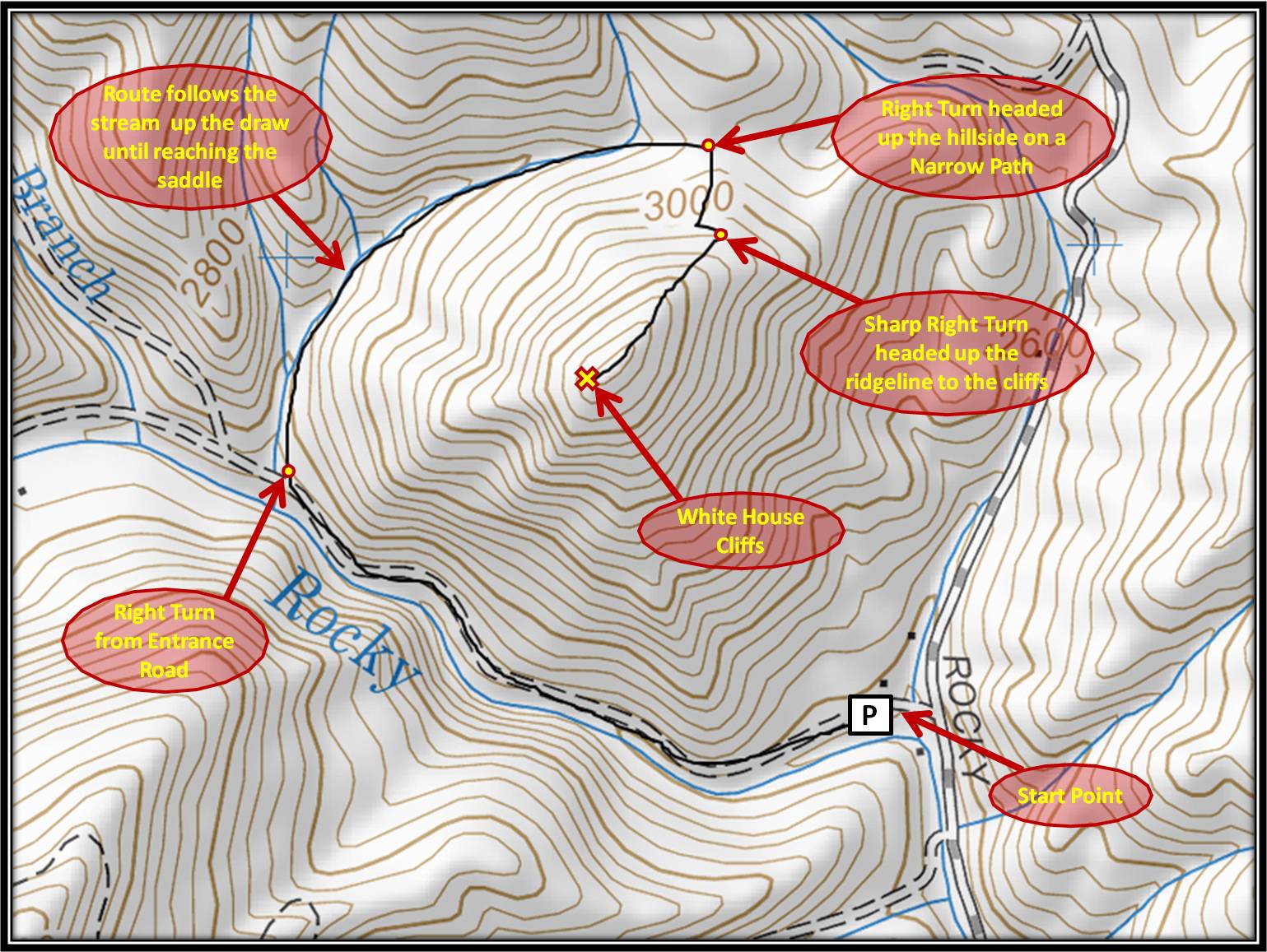
The views from White House Rock Cliffs are phenomenal - especially this time of year when the leaves are beginning to change. But the hike to get there is grueling. The trail is being established (or perhaps, reestablished) and is not well marked or obvious in places. And while the first two-thirds of the hike is relatively easy, the last 1/3 is a calf-burner, straight up a mountain side.  I recommend going on a cool day and that you take some water along.  And because the trail isn't always immediately clear, study the map below to get a sense of its general trajectory as it circles around the mountain.

If you've been on I-26 heading from NC to TN, you may have seen the rugged cliffs off to the west within Rocky Fork, north of Flag Pond, TN, this is known as White House Cliffs.  The links below will show you this view.  It's not an especially long hike, just under 1.5 miles each way. But it's one of the harder hikes I've experienced in this area in terms of vertical climb in a short distance. Nothing is hand-over-hand, just a very steep trail. So be prepared for that!

iPhone panorama of the incredible views (click photo to enlarge)

Once on top, you can explore and climb down the from the steep, rocky pinnacle to the actual rock outcropping that is visible from the interstate. But from what I've read (again, see links below) this is very difficult and also dangerous to do.  But as the dog (and I) were worn out and in need of water, I took some shots from the summit and headed back down the mountain.

Directions: Take the Flag Pond exit off of I-26 (exit #50), at the stop sign turn left onto Higgins Creek Road. Drive ½ mile, til you reach Rt. 23, turn right and travel 2 ¼ mi. thru Flag Pond, then turn left on Rocky Fork Road. Take your time driving up this road, the creek offers amazing cascades and waterfalls. After ¾ mi. you will see a gravel pull-off to the left and a small parking area. Park here (out of the way of the gate) and follow the gravel lane into Rocky Fork on foot. I think of the trail to the cliffs as broken up into three distinct segments....
The main road within Rocky Fork
1. You'll follow the main road (photo left) into Rocky Fork for about 1/2 mile, past the Triple Falls and up and around the bend until you are almost to where the road forks. On your right you'll see a wooden stake with an orange flag tied to it (photo below left). This is the trail head to White House Cliffs Trail.

White House Cliffs Trail Head
2. This next segment follows a small creek bed, with the trail sometimes running along the stream, other times actually in the stream. So old shoes are helpful. In dryer months, this stream doesn't run. After a time it becomes clear this trail is actually part of an old logging road. It's fairly easy to follow the trail at this point and the elevation gain is gradual. Eventually, you'll reach a high point (saddle, gap) where the continuing logging road starts to descend. At this saddle, look to your right and you'll see the trail continues.

Can you see the trail? :)
3. This is where it gets steep. And the trail isn't always so clear. Occasionally you'll find a helpful orange or pink flag, but these are few and far between. Watch your footing and pay attention to where you're going. It's easy to get turned around. You will soon arrive at a very obvious survey marker (photo below), and the trail makes another sharp right hand turn. Pay attention to where you just came from, this is the only point at which I had a hard time figuring out where to go when coming back down the mountain. The trail now become (gasp) even steeper as it follows the ridge up to the top. Keep at it and your efforts will be rewarded with amazing panoramic views.  There are times near the top where the trail is a little unclear, but again, take your time and look things over. This will be helpful when coming back down!


Survey marker where trail takes sharp turn
Additional Descriptions and Resources:
Monkey's Mask (scroll down after clicking)
RATreks
Far Outside the Wire

For a terrific map of the White House Cliffs Trail, click here.
For a helpful map giving an overview of the trails of Rocky Fork, click here.

The photo at the very top was my favorite from my  trip... and it's from my iPhone. So glad I carried up all my gear only to have the iPhone out-perform my Nikon.  Ugh. :P

Update (Spring 2015): The trail has seen more use and is much easier to find and navigate. The best thing you can do is follow study this WH Cliffs Trail map to get your bearings. Wear old shoes for the second section that follows the creek! Very muddy after a rain. We climbed down a bit farther from the top, but it's rough. Rocky, thorny, steep, unsteady. Turned around after a bit. When we got on the interstate headed back home we looked over at the cliffs, and were amazed how far down they are from the top. Glad we didn't continue down to them. From what I've read, it's crazy dangerous to try to head down to the road from the cliffs (which makes sense), so you would have to ascend the peak once again and come back whence you came. :) For me, I'm more than content with the amazing views from the top.

Sunday, September 21, 2014

Osceola Island


Went for a walk around Osceola Island yesterday evening and took some photos with the new iPhone 6. It's amazing how far cell phone camera technology has come in the last 10 years. I think my first flip phone had a whopping 1.3 mega pixels - and the images weren't anything you'd ever print or do much of anything with. Today there are colleges offering iPhone photography courses.

Osceola Island is a terrific place to have a picnic and then explore. It's located a mile below South Holston Dam outside of Bristol, TN. A footbridge leads visitors to a 1.8 mile long gravel trail around the island (map here). On both sides of the island are the unique weir dams you see in the photos. Designed to aerate the river below, the waterfalls only flow when the dam is generating electricity. You can find out when they are generating by clicking here.

Here is a PDF map of the nearby area.

Because the dam generates electricity by pulling water from the bottom of South Holston Reservoir, the water in the river below the dam (called the tailwaters) is very cold. In fact, even on a hot summer day, the water temperature will only be in the mid-50s at midday. Perfect conditions for trout fishing.

Wednesday, March 19, 2014

Trails at Winged Deer Park

Winged Deer Park Trail Map (click to enlarge)
The trails at Winged Deer Park, a city park located in Johnson City, TN, offer a conveniently-located opportunity for city residents to explore a natural environment close to town. The park offers both paved and unpaved (or natural) trails through the forested area of the 200 acre site, in addition to the half-mile paved track that circles the softball fields. I wish I could report that the paved trails are conducive to families with strollers, bicycle riders and those in wheelchairs, but they are often incredibly steep -- precluding a leisurely 'walk in the the woods'. However, the unpaved trails are better designed and allow for a more enjoyable walking/hiking experience as they are of a more reasonable grade. If you haven't visited the park (or at least the wooded section of the park), I'd recommend parking at the lower "Disc Course" parking lot on the backside of the park (click map above) and then walking into the woods to pick up the White Loop Trail. It's steep at first, but then moderates to give visitors the opportunity to explore the woods. Visit late March/early April to see a huge bluebell flower patch on Bluebell Loop (see this post and map below). While a number of years back there were issues of criminal activity in the park, I haven't heard of any issues in the last few years.

Map of trails and disc golf course (click to enlarge)
In addition to the trails, 1/2 mile track and five softball fields, the park offers batting cages, an 18-hole disc golf course, three soccer fields and playground. The nearby lakefront area features two sand volleyball courts, picnic shelter, public boating access, boardwalk, and amphitheater. The park’s historical area features the Robert Young Cabin – one of Johnson City’s oldest dwellings, the Massengil Monument, and the James H. Quillen Historical Tree Arboretum.

For a video introduction to the park, click here. For a google map of its location, click here.

Monday, February 10, 2014

rock creek cascade

A memory is what is left when something happens and does not completely unhappen. 
--Edward de Bono (b.1933) author. 

I set out to take some photos today at Rock Creek Park. Camera charged? check. Backpack? check. Tripod? check. Memory card? Umm...oops.  Of course, I discovered this while composing a different photo standing in the creek, camera set upon the tripod. So here is a photo from my trusty backup, the iPhone.  It did pretty well, and weighed a whole lot less. Image quality... well, fortunately I can see a difference. That's good, otherwise I've wasted lots of money on lenses! Anyway... the intention was there to take a quality image. I like this angle of the walkway at Rock Creek Park outside of Erwin, TN. If memory serves, I'll be back. :)

Friday, October 4, 2013

early autumn color

The early bird gets the worm, but the second mouse gets the cheese. 
--Jon Hammond 

Hope to get out this weekend and find more autumn color. Here's yet another Watauga Lake photo from last weekend. Such a beautiful area we live in!

Monday, September 30, 2013

chameleons

We are like chameleons, we take our hue and the color of our moral character, from those who are around us. 
--John Locke (1632-1704) English philosopher. 

Above: Another look at some early autumn colors along Watauga Lake.

Sunday, September 29, 2013

harmony

Nothing exists without music, for the universe itself is said to have been framed by a kind of harmony of sounds, and heaven itself revolves under the tones of that harmony.
--Isidore of Seville (c. 568-636 AD) Archbishop and saint.

Above: The first glimpse of autumn color along the shores of Watauga Lake.

Wednesday, May 29, 2013

Iron Mountain Gap to Hughes Gap

Located high atop Iron Mountain on the TN/NC line is an old apple orchard, a remnant of a farm that once was here. There are now only a few remaining trees (see above), though efforts have been made to plant others in hopes of maintaining the area. I took the AT out to the first rock outcropping listed below for a nice out-and-back day hike. Along the way, I saw lots of wildflowers - including this beautiful patch of trillium. Most of the trail is moderate in terms of grade, although a few sections get somewhat steep. During winter months, this section of trail offers nice views of Roan Mountain to the east.

The AT section from Iron Mountain Gap to Hughes Gap is approximately 9 miles in length.
0.0 Mi. - TN 107/NC 226 - Small Parking Area at the state line (elev. 3723 ft.)
0.5 mi. - View of Pinnacle Mountain to the west (see previous post here)
0.8 Mi. - View of Unaka Mountain to the west (image right)
1.2 mi. - Old Apple Orchard
2.3 mi. - Rock outcropping (elev. 4426 ft.)
3.4 mi. - Reach summit of a knoll (elev. 4332 ft.)
4.1 mi. - Greasy Creek Gap
6.0 mi. - Blue trail to Clyde Smith Shelter (200 yards)
6.2 mi. - Reach summit of a knoll (elev. 4640 ft.)
6.8 mi. - Cliff overlook (Click here for images and discussion)
6.9 mi. - Reach high point of AT on Iron Mtn near Little Rock Knob (4918 ft. elevation)
9.1 mi. - Reach Hughes Gap (elev. 4040 ft.)

Directions: Take TN Route 107 (Limestone Cove Road) ten miles east from Unicoi, TN, or NC Route 226, four miles west from Buladean, NC to the state line, where there is a wide gravel pull off area. After parking, look toward the TN side and across the road and you'll see where the AT heads north toward Hughes Gap.

Saturday, May 25, 2013

Vintage

This impressive railroad viaduct over Boones Creek Road in Johnson City, TN was built in 1908. The VW Bus ahead of me was built in 1973. :)

Saturday, May 18, 2013

top dog

The better I get to know men, the more I find myself loving dogs.
--Charles de Gaulle (1890-1970) French General and President. 

Above: "Blue" anxiously waiting to resume swimming and playing fetch at Sycamore Shoals State Park in Elizabethton, TN.

Saturday, July 21, 2012

Breakfast with the Balloons


One of the most popular events of the annual Kingsport Fun Fest is "Breakfast with the Balloons". The overcast weather and low visibility prevented the launch, but still, approximately 10 balloons were inflated to give spectators a chance to see the fascinating process of preparing the balloon for launch (takes only 10-15 minutes).  Fun Fest concludes tonight with a Lynyrd Skynyrd concert and a fireworks display.

You must live in the present, launch yourself on every wave, find your eternity in each moment.
--Henry David Thoreau (1817-1862) American Essayist, Poet and Philosopher.

Monday, April 30, 2012

Lakeview Marina

Went to lunch yesterday at the "Marker 2 Grille" at Lakeview Marina located near the Tri-Cities Airport. I've always heard about the marina, but never visited. What a great find! Wonderful food, terrific view! The outdoor pavillion is huge - I imagine it's a lot of fun at night! From their Facebook page: "THE REGION'S LARGEST & BEST LAKESIDE DECK on BOONE LAKE! featuring GREAT LIVE ENTERTAINMENT DAILY & FANTASTIC FOOD!"

Click here to view their FB page, which has a map with directions and restaurant hours.

Wednesday, March 28, 2012

Bitter Clingers

When one has nothing left to lose one becomes courageous. We are timid only when we have something left to cling to.
--Don Juan Matus   

This is a iPhone photo of some leaves on a beech tree in my woods -- just can't seem to accept the fact that it's spring yet. I'm loving the iPhone, by the way -- my favorite photo app is called Camera Awesome -- lots of great controls and editing features. Most of them are completely over the top, but still it's fun to see what you can produce with a camera phone. We've come a long way from the horrible, grainy images produced by our original cell phones.

Saturday, February 18, 2012

Watauga Point Trail


Nature is God's greatest evangelist.
--Jonathan Edwards (1703-1758) American minister. 

Even though the picnic area at Watauga Point is closed for the winter, there's a little known trail that gives visitors beautiful views of the lake. This short (only 0.4 mi long), easy, looped trail begins at the overflow parking lot at Watauga Point and is accessible year round. Half-way through the hike, there's an open, beach-like area -- the perfect place to take the dog for a swim.

Another nearby trail to consider is the Carden's Bluff Trail.

Directions: Take 19E to Hampton, TN, turn east on Highway 321/67 going toward Mountain City.  Travel approximately 6 miles, turn left into Watauga Point Recreation Area, park in the overflow lot to your right, trailhead is clearly marked.