Showing posts with label South Holston Dam. Show all posts

Thursday, August 27, 2015

set us free


Gracious God,
Turn us loose, but never let us go.
Set us free, but never let us go.
Let us find our own path, but never let us go.
Let us work it out for ourselves, but never let us go.
Let us suffer from our own mistakes, but never let us go.
Receive us to Thyself, never let us go.
We leave this Thy house, but never let us go.
In the name of Jesus Christ, Amen.

 --Fred Craddock (1928-2015) Minister, Professor and Author (Benediction from his sermon, "The Cloud of Witnesses")

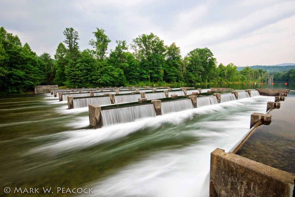
Some scenes from the beautiful area beneath South Holston Dam of the Weir Dam at Osceola Island. For more images, discussion and directions, click here.


Monday, August 24, 2015

holston rainbow


The true harvest of my life is intangible - a little star dust caught, a portion of the rainbow I have clutched. 
--Henry David Thoreau (1817-1862) American Writer and Philosopher.  

Above: Rainbow over South Holston Lake

Sunday, September 21, 2014

Osceola Island


Went for a walk around Osceola Island yesterday evening and took some photos with the new iPhone 6. It's amazing how far cell phone camera technology has come in the last 10 years. I think my first flip phone had a whopping 1.3 mega pixels - and the images weren't anything you'd ever print or do much of anything with. Today there are colleges offering iPhone photography courses.

Osceola Island is a terrific place to have a picnic and then explore. It's located a mile below South Holston Dam outside of Bristol, TN. A footbridge leads visitors to a 1.8 mile long gravel trail around the island (map here). On both sides of the island are the unique weir dams you see in the photos. Designed to aerate the river below, the waterfalls only flow when the dam is generating electricity. You can find out when they are generating by clicking here.

Here is a PDF map of the nearby area.

Because the dam generates electricity by pulling water from the bottom of South Holston Reservoir, the water in the river below the dam (called the tailwaters) is very cold. In fact, even on a hot summer day, the water temperature will only be in the mid-50s at midday. Perfect conditions for trout fishing.

Sunday, January 30, 2011

on self-reliance

Give a man a fish and he will eat for a day. Teach him how to fish and he will sit in a boat and drink beer all day.
~Author Unknown  

Fishing in the shadow of South Holston Dam outside of Bristol, TN

Sunday, August 8, 2010

wide open

Where there is an open mind there will always be a frontier.
--Charles F. Kettering (1876-1958) American engineer, inventor

A panoramic view of South Holston Dam comprised of seven images stitched together effortlessly by Photoshop CS5 (click photo above to enlarge). It amazes me how the software figures out where each photo goes, lining up the rocks and mountains and shoreline, and then blending them together so well. Only in one place is it obvious where there is a seam -- and that has to do more with my use of a polarizer filter on my lens than with Photoshop. My tripod has a 'ball-head' on it, so it's of no use for panoramic photos, so for this I just lined up the grid in my viewfinder with the water line and tried to keep everything as level as possible. You want to make sure you keep the same exposure for each component image, so keep the camera on manual - and...it's probably best to take off the polarizer before you start. :)

Construction of South Holston Dam was begun in 1942, but not completed until 1950.  This impressive earth and rock dam (on the right of the photo) is 285 feet high and spans 1600 feet across the South Holston River. When completed, the dam resulted in the South Holston Reservoir, which extends for 24 miles, with 168 miles of coastline. More info here.

Directions: From the intersection of routes 394 and 421 south of Bristol, continue 2.9 miles south on 421 (toward Shady Valley). Turn right onto Emmett Road/Holston View Dam Road. Continue for 1.6 miles (bear right at the fork) and you'll see the Osceola Island/Weir Dam recreation area on your left. Continue on Holston Dam View Road for another 2 miles to the top of the dam. Beautiful views! 

Wednesday, August 26, 2009

misty morning

A misty morning does not signify a cloudy day.
--Proverb

The footbridge leading visitors to the walking trails on Osceola Island near the South Holston Dam. Click here for discussion and directions.

Tuesday, August 25, 2009

A River Runs Through It

In our family, there was no clear line between religion and fly fishing.
--Norman Maclean (1902-1990) author of A River Runs Through It

The tailwaters of the South Holston are a nationally recognized trout fishery and, from what I saw, a very popular place to be early on Saturday mornings. Pictured above is Frank Newcomb, a senior education major at Milligan College. The river is located directly below South Holston Dam which discharges water from the bottom of the lake to generate electricity, resulting in a constant cold temperature all year -- perfect for trout.

Sunday, August 23, 2009

Appalachian Blues

Blue color is everlastingly appointed by the Deity to be a source of delight.
--John Ruskin (1819-1900) English Writer

This shot was taken Saturday at 6:45 am from the top of South Holston Dam outside of Bristol, TN. To soften the clouds and still the waters of South Holston Lake, I left the shutter open for 25 seconds.

Directions: From the intersection of routes 394 and 421 south of Bristol, continue 2.9 miles south on 421 (toward Shady Valley). Turn right onto Emmett Road/Holston View Dam Road. Continue for 1.6 miles (bear right at the fork) and you'll see the Osceola Island/Weir Dam recreation area on your left. Continue on Holston Dam View Road for another 2 miles to the top of the dam. Beautiful views!

Tuesday, April 8, 2008

fishermen turned philosophers

Scholars have long known that fishing eventually turns men into philosophers. Unfortunately, it is almost impossible to buy decent tackle on a philosopher's salary.
--Patrick F. McManus (b.1933) writer

Another fishing shot (this one is of the low church variety -- see the post two days ago to read why) from South Holston Lake. The two fisherman standing up in that little boat shows the mammoth scale of the water intake tower of South Holston Dam. And it's hard to not notice that even with all of our wonderful spring rains, the lake level is still way down. To be honest, I'm not sure if I like this shot or not -- it's definitely not balanced -- the subject matter is isolated to one corner of the frame with no strong diagonals or sense of drama or movement. I suppose I could say it demonstrates the "rule of thirds" and what advertisers say about the creative use of "white space." But admittedly, it's a pretty boring shot. And maybe that's the point of it. It's a quiet, still scene. I think it captures the misty and cloudy feel of the day last Saturday. I suppose the fishermen-philosophers among us might find more to say about it, but that's all I have tonight!

Wednesday, June 27, 2007

Severe Dought

This is a sad view of the low water level of South Holston Lake taken from atop the dam outside of Bristol, TN. Today's Johnson City Press reports that the lake is 12 feet below its normal level for this time of year. But after the driest Spring on record, what else could we expect? The US Drought Monitor still has us listed as experiencing a "severe drought" -- what's scary is that they have two levels of severity beyond that: "extreme" and "exceptional." Let's hope the scattered thunderstorms forecast for this week will help reduce the 12 inch rain deficit we've got.

Tuesday, June 26, 2007

Weir Dam, Part II

I guess I'm not quite ready to move on from yesterday's post re: the Weir Dam south of Bristol, TN. This is the other photo I want to share -- a close up, cropped view of some of the waterfalls created by the Weir Dam itself. I was happy with the lighting of this one and thought it conveyed (as well as I could) the special power and beauty of the place.

Monday, June 25, 2007

Weir Dam, Part I


South of Bristol, TN, just below the South Holston Dam, is a wonderful recreation area on Osceloa Island. Although folks in Bristol know all about the Weir Dam, I don't find much online about it. If you know of any good websites, please comment below. But this is a great place to take visitors to introduce them to the beauty of northeast Tennessee. There's fishing, picnic tables and a nice trail that makes a 1.5 mile loop around the island. But the real attractions are the weir dams. They were constructed in 1991 on both sides of this island to add oxygen to the Holston River when the TVA is not generating electricity. As you can see, it's as if the TVA constructed 72 waterfalls (12 rows of 6), all of them thundering at once. To hear what this sounds like, click here for video (this is of the smaller weir dam on the far side of the island). Keep in mind that this scene only happens during times when the TVA is generating at the South Holston Dam (about a mile upstream). So before you head out, go online (here) to see their schedule for releasing water (Click on South Holston in the "Choose a reservoir" drop down menu).

Directions: From the intersection of routes 394 and 421 south of Bristol, continue 2.9 miles south on 421 (toward Shady Valley). Turn right onto Emmett Road/Holston View Dam Road. Continue for 1.6 miles (bear right at the fork) to the recreation area on your left.

Where to next? After taking in the sights and sounds at Osceola Island, get back on Holston Dam View Road and drive 2 more miles to the top of the dam. Here you will see a beautiful view of South Holston Lake.