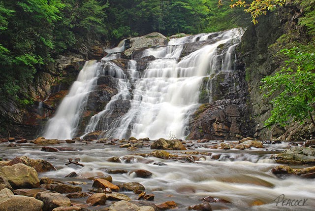
This is probably the most popular, and arguably the most spectacular, waterfall in northeast Tennessee. But it's not necessarily the easiest to get to. The most popular route is to hike in from the top. It is a beautiful 1.2 mile trail that is level for much of the way with the first part actually following an old railroad bed. But the last quarter mile goes straight down. They've done a great job putting in stone steps all the way to the bottom, but it's still a difficult descent and a strenuous hike going back up. I was very surprised to see some folks down at the falls wearing flip-flops and carrying babies, they must be much more sure-footed than I (which actually isn't saying too much!). I'd recommend a good pair of hiking boots and on a hot day, a bottle or canteen of water. The 55' waterfall (also known as Laurel Fork Falls) is powerful and stunning after some heavy rains. As I mentioned, this one is popular, so I'd recommend starting out early and/or going on a weekday if possible. The other trail to the falls, which starts from just north of Hampton, TN, is described
here.
Click here to learn more about the Laurel Fork Railroad. Click
here and
here and
here for more information and discussions about this popular waterfall.
Directions: Hampton, TN is located between the cities of
Elizabethton and Roan Mountain on Highway 19E. Once in Hampton, turn north onto route 321/67 toward Mountain City. Drive 0.8 miles and turn right immediately in front of the Citizen's Bank onto Dennis Cove Road. Take this incredibly
curvy and steep road for exactly 4 miles to a parking area and
trailhead on your left. From here, begin your hike on the main trail on your left (which is actually the AT -- look for the white slashes on the trees. The smaller trail on your right meanders through some camping areas).
Click here for map.
Here's a really good video of the hike into Laurel Falls on the AT from Dennis Cove.
This video is also well done, describing the hike and giving some good photography tips.

There is also a very step trail to the left. It'll take you to the top and another set of falls on up the creek a lil more.
ReplyDeleteWe were accompanied by a collie dog by name of Corkie, she is a local pet who stayed with us on the hike. In addition to this hike being a wonderful trek, Corkie just added to the experience.
ReplyDeleteShe made our hike special. Just wondering if she is still there waiting on the next group to befriend her and let her come along.
Enjoyed the hike is a good hike. The only downfall is that the signs posted where to go down to falls is not very good missed the sign. came in on the lower side and then back up which added another hour to the hike. But would highly recommend the hike.
ReplyDelete