Thursday, June 28, 2007

A silent preacher

There is not a flower that opens, not a seed that falls into the ground, and not an ear of wheat that nods on the end of its stalk in the wind that does not preach and proclaim the greatness and the mercy of God to the whole world.
--Thomas Merton (1915-68)

Wednesday, June 27, 2007

Severe Dought

This is a sad view of the low water level of South Holston Lake taken from atop the dam outside of Bristol, TN. Today's Johnson City Press reports that the lake is 12 feet below its normal level for this time of year. But after the driest Spring on record, what else could we expect? The US Drought Monitor still has us listed as experiencing a "severe drought" -- what's scary is that they have two levels of severity beyond that: "extreme" and "exceptional." Let's hope the scattered thunderstorms forecast for this week will help reduce the 12 inch rain deficit we've got.

Tuesday, June 26, 2007

Weir Dam, Part II

I guess I'm not quite ready to move on from yesterday's post re: the Weir Dam south of Bristol, TN. This is the other photo I want to share -- a close up, cropped view of some of the waterfalls created by the Weir Dam itself. I was happy with the lighting of this one and thought it conveyed (as well as I could) the special power and beauty of the place.

Monday, June 25, 2007

Weir Dam, Part I


South of Bristol, TN, just below the South Holston Dam, is a wonderful recreation area on 
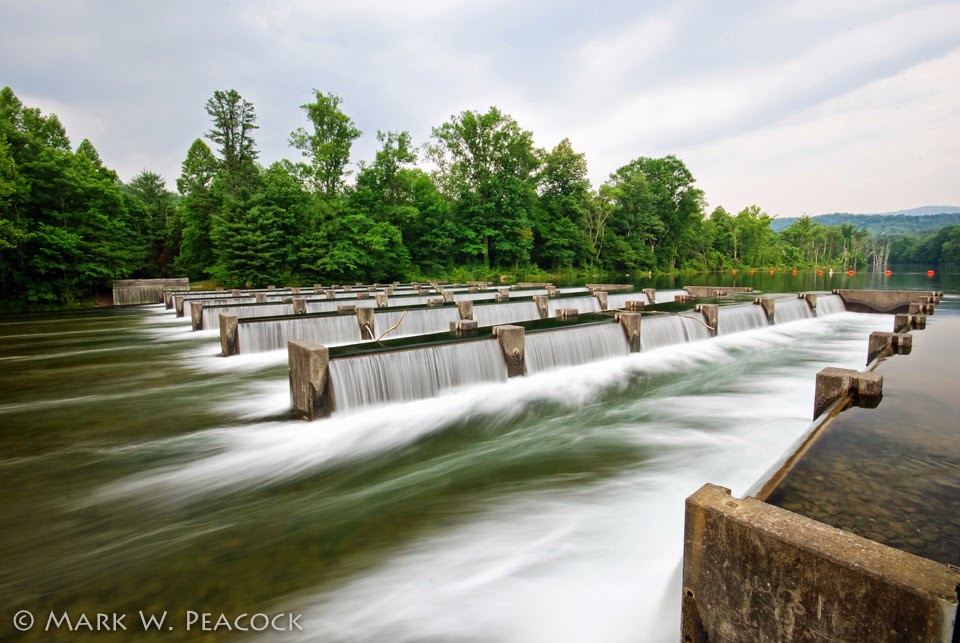
Osceloa Island. Although folks in Bristol know all about the Weir Dam, I don't find much online about it. If you know of any good websites, please comment below. But this is a great place to take visitors to introduce them to the beauty of northeast Tennessee. There's fishing, picnic tables and a nice trail that makes a 1.5 mile loop around the island. But the real attractions are the weir dams. They were constructed in 1991 on both sides of this island to add oxygen to the Holston River when the TVA is not generating electricity. As you can see, it's as if the TVA constructed 72 waterfalls (12 rows of 6), all of them thundering at once. To hear what this sounds like, click here for video (this is of the smaller weir dam on the far side of the island). Keep in mind that this scene only happens during times when the TVA is generating at the South Holston Dam (about a mile upstream). So before you head out, go online (here) to see their schedule for releasing water (Click on South Holston in the "Choose a reservoir" drop down menu).

Directions: From the intersection of routes 394 and 421 south of Bristol, continue 2.9 miles south on 421 (toward Shady Valley). Turn right onto Emmett Road/Holston View Dam Road. Continue for 1.6 miles (bear right at the fork) to the recreation area on your left.

Where to next? After taking in the sights and sounds at Osceola Island, get back on Holston Dam View Road and drive 2 more miles to the top of the dam. Here you will see a beautiful view of South Holston Lake.

Sunday, June 24, 2007

Gray Fossil Site

It doesn't open until August, but already it's a sight to see. After fossils were discovered in 2000 during the widening of the nearby highway, plans were made for a natural history museum outside of Gray, TN. Scientists estimate the fossils are 4.5 to 7 million years old. If the museum exhibits are even half as interesting as the building itself, they'll have quite an amazing attraction for Washington County and East Tennessee. For more information, click here and here and here.

Directions: From I-26, take exit 13 (Gray) and head west (turn left, away from town) on Route 75 (Bobby Hicks Highway) for 1.8 miles. The museum is on your left.

Saturday, June 23, 2007

A glimpse of grandeur


The grandeur of nature is only the beginning. Beyond the grandeur is God.
--Abraham Joshua Heschel (1907-72)

A view from one of my favorite places to view sunsets, the Beauty Spot in Unicoi County, TN. [Click photo to enlarge] Click here for a post listing all there is to see and do on Unaka Mountain.

Friday, June 22, 2007

The Great Rhododendron

Maybe not as striking as the Catawba Rhododendron in bloom right now at the Rhododendron Gardens atop Roan Mountain, the Great Rhododendron covers the mountains of Appalachia from Maine to Georgia. Also known as the "Great Laurel," its white to pink blooms have distinctive greenish-yellow markings within them. Often when hiking the AT and other trails this time of year, the fallen blooms line the path. And if you've ever been hiking anywhere around the mountains of TN and NC, you know that it's more like a tree than a shrub, growing up to 25 feet tall and in such density as to make areas impassible.

By the way... The Roan Mountain, TN Rhododendron Festival is this weekend! Click here for information.

Thursday, June 21, 2007

Butterfly Abstract

I already posted a butterfly picture last Saturday (scroll down or click here), but as my posts this week seem to be taking on a 'photo tips' theme, another butterfly picture came to mind. This photo has been cropped. A lot. That's another benefit of digital - it's so easy to re-frame the photo, long after the butterfly has flown away. In this case, the photo was largely out of focus and was just about deleted. But then I noticed an interesting pattern of tiny flowers ringing the butterfly's colorful wings. I wish I could tell you that I saw this when I was snapping away -- but it was only later, when I had the time to really inspect the scene that this interesting detail revealed itself. So next time you're going through your photos, look twice. It's an opportunity to re-frame the scene, and create an entirely different look.

Wednesday, June 20, 2007

Getting Perspective


Here's another bit of advice I read somewhere that changed the way I take pictures: Find a different perspective. The vast majority of all photos are taken from a position 5'2" to 6'2" off the ground. It's the perspective we see everyday as we make our way through life. We look at snapshots others have taken and we quickly recognize the perspective from which it was taken -- the vantage point is familiar to us. To take more compelling photos consider getting low to the ground or climbing to a higher point. Your subject matter may still be ordinary, but you'll cause others to look twice and consider another perspective.

The photo above was taken from the position of lying down on a rock in the middle of the Doe River within the Roan Mountain State Park.

Tuesday, June 19, 2007

Considering Lilies

A great bit of advice I read somewhere is to use construction paper as a background when shooting flowers. For this shot, I put the camera on a tripod (very low to the ground) and held a blue folder in the background, far enough away that it would be blurred. I tried a few different colors, but ended up liking blue the best against the orange tiger lily. Another happy accident led to the picture below. I set up the tripod, looked through the viewfinder, only to find that I was way too close. But then I realized there was something very interesting in just isolating the lily's filaments (I think that's what they're called!). I guess this is all an attempt to follow scripture.Consider the lilies of the field, how they grow; they neither toil nor spin; yet I tell you, even Solomon in all his glory was not arrayed like one of these.
--Jesus (Matthew 6:28)

Monday, June 18, 2007

Rhododendron Gardens


Referred to as a "Jewel of Nature," the rhododendrons on top of Roan Mountain are putting on their annual show. I'd say they are at their peak this week (right now!) leading up to the Rhododendron Festival this weekend. The rhododendron gardens are a breathtaking display of hundreds upon hundreds of Catawba rhododendrons carpeting the mountainside. The three dollar per car fee is well worth it to see this incredible display of nature.

Directions: Take Route 19E to the town of Roan Mountain, turn onto Route 143 and travel 12.8 miles to the TN/NC state line (Carver's Gap). On your way up the mountain, you'll pass through the Roan Mountain State Park. Eventually, you leave the state park and enter the national forest. At Carver's Gap turn right, following the signs to the Rhododendron Gardens two miles up!

Other things to do: After walking the paths through the gardens, drive on to the trail head for the Roan High Bluff -- a short hike will take you to a breathtaking overlook. Another hike to consider is to stop at Carver's Gap on your way down from the gardens and to take the Appalachian Trail to the top of Round Bald -- this short hike will give you an amazing 360 degree views of the mountains.

Sunday, June 17, 2007

Roan Mountain State Park


A view of the Doe River as it flows through the Roan Mountain State Park outside of Roan Mountain, TN. While the Appalachian Trail and the other hiking trails at the top of the mountain (within the National Forest) are always popular choices (especially when the Rhododendron and Flame Azalea are blooming), there are more than 12 miles of hiking trails within the state park. There's also a terrific campground in the state park, cabins to rent, fishing, swimming, volleyball, tennis and picnic shelters. An authentic old homestead is located within the park that is open for tours. The campground and cabins are the perfect location for planning a visit to the area - from this central location you can take in all of Roan Mountain, and set out to see nearby attractions such as Elk River Falls, Grandfather Mountain, and the Blue Ridge Parkway. The Roan Mountain Rhododendron Festival is held at the park usually the third or fourth weekend in June.

Check out the official town website for more information about the Festival and check out the official park website for directions, a park map and additional information.

Saturday, June 16, 2007

Achieving Beauty

We delight in the beauty of the butterfly, but rarely admit the changes it has gone through to achieve that beauty.--Maya Angelou

This butterfly, a great spangled fritillary, was unusually cooperative with me - it was content to hang out among the crown vetch and the butterfly milkweed. [click photo to enlarge]

Friday, June 15, 2007

Rain, rain, come again!

Following the driest spring on record in east Tennessee (only 5.67" of rain for this spring, including only 0.76" for all of May!), these dry fields near the Tri-Cities Airport in Sullivan County could use a good rain. While much of the area received a soaking yesterday, the airport reported only about a quarter of an inch of rain. So it comes as no surprise that the drought monitor has most of our region listed as being in a "severe drought."

Thursday, June 14, 2007

Red Fork Falls


This is one of the most beautiful falls in our region, and while it's a short hike from the parking area, it's actually one of the toughest falls to view. The half-mile hike is extremely steep and often very slippery. Many people have been seriously injured attempting to view these falls. You don't so much hike to the falls as you actually climb down to them -- no steps here, just rocks and tree stumps to hold onto. So while it's an amazing waterfall, this trip isn't for everyone. (I don't even bring my dog to this one!) Take your time and use caution and common sense -- for instance, wear shoes with ankle support and stay off the slippery rocks at the top of the falls! If you aren't able to visit, take a look at more of my pictures. Red Fork Falls is actually a series of eight falls. The first three photos here show various views of the main 60' waterfall. The final photo is the corkscrew that the water enters immediately after the main falls -- the water enters from the right and zig-zags through the narrow channel to another cascade. It's an amazing place to visit -- but with all the climbing, you'll be sore the next day or two!

Directions: From I-26 take the Unicoi exit (#32). At the end of exit ramp turn east towards town. At the stop sign, turn right onto Unicoi Road (which is also known locally as the Erwin Highway) and proceed for 0.7 miles. Follow the signs pointing to the Cherokee National Forest by turning left onto Rt. 107 (Limestone Cove Road). Drive 7.8 miles, turn right on Red Fork Road (it's also referred to as Unaka Mountain Road). Proceed up the mountain for 1.2 miles to a small parking area and trail head to your right -- marked only with a big red dot on one of the trees. After a short walk down the initial part of the trail, you'll cross the creek, then turning right, you'll cross another one. Continue a short ways more and your near-vertical descent will commence!


Note: While you won't need a high clearance vehicle to get to Red Fork Falls, I'd recommend one if you wish to continue on Red Fork Road to Stamping Ground Ridge, Horseback Ridge, Unaka Mountain Overlook and Beauty Spot. Click here for a detailed post listing all there is to see and do on Unaka Mountain.

Before venturing out, please read my warnings, safety tips and disclaimers.

Wednesday, June 13, 2007

Rough Ridge Overlook


One of the most best overlooks I've found on the Blue Ridge Parkway is at mile #302.8 just north of the Linn Cove Viaduct and Grandfather Mountain. It's one of those overlooks that's easy to drive by, because you can't immediately see anything but a parking area. But take the short, moderately steep 1/2 mile trail, and you'll be rewarded with magnificent views of the viaduct, Grandfather Mountain and layers of mountain ridges to the south and east. After you get to the wooden platform seen above, continue climbing another half mile and you'll be rewarded with even more breathtaking views. The trail can be slick and muddy after a rain - wear old shoes. Because of the narrowness of the path, pets are not allowed.

The trail to the lookout is part of the 13.5 mile Tanawha Trail which parallels the parkway and leads to Price Lake (Mile 297) to the north and Beacon Heights (Mile 305) to the south. Tanawha is the Cherokee word for "great hawk or eagle" -- which if fitting given the soaring views of the mountains it offers. Click here for an interactive map of the trail.


Above is a beautiful bridge found on the trail to Rough Ridge, one of many along the Tanawha Trail. Perhaps the best known of these graceful arched bridges is Boone Fork Bridge a few miles to the north on the Blue Ridge Parkway at mile 300.

Tuesday, June 12, 2007

Laurel Creek Falls

Not to be confused with Laurel Falls near Hampton, TN -- Laurel Creek Falls is a small waterfall west of Boone, NC. It is known locally as Trash Can Falls. In case you're wondering, no, it's not all junked up. Just the opposite, the setting for this waterfall is quite nice. Huge rock formations surround a cascading stream, forming pools perfect for a summer swim. While it may not be the biggest waterfall around, it gets points for its unique criss-cross affect and for its cool setting. I heard about it by reading the Blue Ridge Blog -- which is a favorite source of information, entertainment and inspiration. Thanks, Marie!

Directions: Located west of Boone off of Route 321, it is 5.4 miles west of the junction of routes 421 and 321. As you head west, look for a pull-off/parking area on your right across from Laurel Creek Road. Park here and then cross Route 321. A 0.15 mile trail leads to the falls pictured above. Another waterfall, Watauga Falls, is located 0.2 miles further west on Route 321 (I haven't visited that one yet).

Monday, June 11, 2007

Bass Lake

In 1901 textile magnate Moses H. Cone, also known as the Denim King, built a summer home outside of Blowing Rock, NC. Known as Flat Top Manor, today it houses the Southern Highlands Craft Guild, which sells and displays crafts from the region. The home can be accessed at mile #293 on the Blue Ridge Parkway. Twenty-five miles of hiking and horse trails wind through the 3,500 acre estate of rolling hills, orchards, forests and two lakes (Bass Lake and Trout Lake). Click here to read more of the history of the park. To see my previous Bass Lake posts, click here.

Bass Lake (pictured above) is easily accessed on Route 221 south (a.k.a. Yonahlossee Road) just outside of Blowing Rock. Lined with rhododendron and mountain laurel, the lake offers a 0.7 mile loop, perfect for an evening stroll or jog -- or a great place to take the grandkid fishin'. Click here for a map of the area.

If you're heading that way, here are some places to consider visiting...
Grandfather Mountain
Linn Cove Viaduct
Rough Ridge Overlook
Beacon Heights Overlook
Price Lake
Moses Cone Estate
Bass Lake
(If you have other places in the area to recommend, please leave us a comment below!)

Sunday, June 10, 2007

Farmhouse Gallery and Gardens

Above: A peacock roaming the grounds of the Farmhouse Gallery and Gardens, located between Johnson City and Unicoi, TN. Click here to go to their website.

Saturday, June 9, 2007

Chapel View

I was given the opportunity this week to climb up the ladders within the steeple of Seeger Chapel at Milligan College to take pictures of the campus. I'm not a big fan of ladders or of heights, but it was all worth it to get a different perspective of Milligan and the surrounding area. According to Google Earth, the towers atop Buffalo Mountain are only 3.3 miles away. [click photo to enlarge]

Friday, June 8, 2007

Kingsport Church Circle

Known as the "Model City," Kingsport, TN has a unique layout. According to the Tennessee Encyclopedia of History and Culture, "Kingsport was the first economically diversified, professionally planned, and privately financed city in twentieth-century America." The main street through the downtown shopping district leads directly to a round-about known as Church Circle. Here, four large, brick churches with beautiful white steeples line the circle. Three of them are pictured above (click photo to enlarge). The historical marker located there reads as follows...

Church Circle
This Kingsport landmark was designed by railroad engineer William Dunlap and refined by city planner John Nolen as an original part of the 1919 City Plan. Church Circle is one of the cornerstones of planned urban design with its "spoke and wheel" street pattern. It is also listed on the National Register of Historic Places. The Bank Building on Church Circle was the site of the Kingsport Inn, a hotel and social meeting place before it closed in 1960.

For a map of the area, click here. For an amazing arial tour video of Kingsport from photographer Earl Carter, click here. Also, Earl has put together a beautiful church circle slideshow/video here.

Thursday, June 7, 2007

Shine

We are told to let our light shine, and if it does, we won't need to tell anybody it does. Lighthouses don't fire cannons to call attention to their shining- they just shine.
--Dwight L. Moody

And as we let our own light shine, we unconsciously give other people permission to do the same.
--Nelson Mandela

Wednesday, June 6, 2007

Bluets, Beauty and Blaise


Beauty is a harmonious relation between something in our nature and the quality of the object which delights us.-- Blaise Pascal, 1623-1662

These tiny flowers were found lining the trail up to Round Bald near the TN/NC border. By the way, while the rhododendrons are blooming at Carvers Gap, those at the Rhododendron Gardens high atop Roan Mountain are still a couple of weeks away.

Tuesday, June 5, 2007

Unaka Mountain Balds


As if the view at the Beauty Spot wasn't enough...next time you visit, take the Appalachian Trail north for 1.15 miles. This fairly level (easy) hike will take you through woods filled with ferns and will soon lead you to another bald at "Deep Gap" that offers more views and lots of wild flowers. (Okay, the views aren't as great as those at the Beauty Spot, but it's still beautiful!). You could just as easily drive to it, as the Unaka Mountain Road (aka Red Fork Road) passes right by. However, the best way to experience and appreciate this second bald is to emerge from the woods up above and walk through the grassy meadows, following the white slashes (indicating the Appalachian Trail) on the fence posts.

No one really knows what causes these balds -- some blame severe forest fires, others say overgrazing of livestock or buffalo caused them. Today, the balds are periodically mowed to maintain the bald and to provide a habitat for wildlife. They offer some of the best panoramic views of the mountains.

Top photo: Deep Gap. Bottom: Beauty Spot.

Directions: From I-26 take the Erwin Main Street Exit (#36), at the end of the ramp turn east toward town and you will immediately arrive at a stop light. Turn right onto Rt. 107 and drive 1/2 mile, turn left at stop light onto Rock Creek Road (Rt. 395) -- continue on for 6.5 miles to TN/NC line (called Indian Grave Gap) and then take the gravel road to the left (you'll need to have a high clearance vehicle for this rough road). After 2.1 miles you'll come to a fork, stay right and you will immediately arrive at the Beauty Spot. Walk up the path that leads to the top of the bald and then turn left and follow the AT north for 1.15 miles to Deep Gap. Map

Click here for a post listing all there is to see and do on Unaka Mountain.

Monday, June 4, 2007

Elizabethton Covered Bridge


Built for $3000 in 1882, the covered bridge in Elizabethton, TN has stood the test of time. The 137 foot long bridge, which spans the Doe River, has become the most recognized and photographed landmark in Carter County. Click here to learn more about the bridge's 125 year history. It wasn't very long ago that you could still drive across the bridge -- today however, only pedestrian traffic is allowed. The 40th annual Covered Bridge Festival begins this week and runs from June 6-9th and includes music, arts and crafts, classic cars, food and, of course, fun.

Sunday, June 3, 2007

Blue Plum Festival

The annual Blue Plum Festival which features music and the arts (along with plenty of food) concluded in Johnson City last night. I've always wondered why it's named "blue plum." I suspected it was chosen to draw attention to the blues/jazz music that is often featured. Perhaps, I thought, it's also a subtle nod to the fact that Johnson City was once referred to as "Little Chicago" (which is known for its blues music). However, standing next to Fountain Square downtown I looked over and read the historical marker which says the following...

Johnson City
Incorporated - December 1, 1869
The town was formerly known as Green Meadows, Blue Plum, Johnson's Depot, Haynesville, then Johnson city. It is situated on land grants of 1782 to Robert and Joseph Young and in 1792 to Joseph Tipton. The town charter was repealed in 1879, but reincorporated in 1885. The name honors Henry Johnson, prominent merchant and postmaster. As industrial and educational center, it is the home of Milligan College, East Tennessee State University, and Steed College.
So now I know. But then another question arose, what the heck is Steed College?!? From the few references I could find, it was a business college that existed in Johnson City from 1940-1982.

Click here for a site detailing the history of Johnson City, TN.

Saturday, June 2, 2007

Elizabethton Linear Path


In recognition of National Trails Day (which is today), I thought I'd write about a trail I recently discovered. The plans for the Elizabethton linear path are quite ambitious. Eventually the path will stretch from near the covered bridge downtown to Sycamore Shoals Park on the west side of town. A one mile section of the path following the Watauga River has already been completed running from the Old Bristol Highway Bridge near McDonalds to an area behind the new Lowe's store. I love that communities across our region are developing linear trails and greenways. They unite far-off corners of a community, draw attention to a city's natural beauty (like the Doe and Watauga Rivers in Elizabethton) and encourage citizens to get out an exercise. For more information about greenways in Tennessee, click here. Read read about Erwin's linear trail, click here.

Directions: The access point for the path is not especially well-marked. From Elk Avenue (aka Routes 67/91/321) turn north between the Rite Aid and the Krystal onto W. Mill St. After passing the Elizabethton Twins baseball stadium, turn left onto Ash St. After 1/10 mile, turn left onto W. Riverside Street.

Friday, June 1, 2007